LANDSCAPE TRAJECTORIES: SEA LEVEL RISE AND FUTURE LANDSCAPES
Janet Stephenson, Centre for Sustainability, University of Otago
The author thanks Professor Martin Manning and two other anonymous reviewers for their helpful feedback on the manuscript.
Looking out over a quiet sea lapping the shore on a sunny day, it is almost inconceivable to think that it is inexorably rising. The globe is locked into a future of sea level rise of anywhere between 30 cm and 1 metre by 2100, and possibly much higher by that date, if ice sheets in Antarctica and Greenland melt rapidly. New Zealand, with the ninth or tenth longest shoreline of any nation (by most measures), and a small population that loves living near the coast, cannot afford to ignore this looming problem. Importantly, the changes that will impact on low-lying coastal areas aren’t just the rise of the sea itself, but the combination of this with more frequent extreme weather events, erosion, rising groundwater, flooding, and ponding. There are innumerable dimensions to the challenges this raises, and one of those dimensions is what it means for coastal landscapes of the future.
Landscapes are dynamic; always incrementally changing through natural processes and the everyday interactions between people and place. From time to time more significant changes occur, usually the result of a purposeful development process, or the outcome of a sudden natural hazard such as a flood or earthquake. With developments, change is predictable and controllable. The individual or organisation that has a development in mind must, these days, develop in accordance with the RMA processes and relevant district and regional plans. Most natural hazards, in contrast, are relatively unpredictable and uncontrollable, in the sense that the event cannot be prevented even if the risk is understood. Even if measures have been put in place to mitigate risk and build resilience, there is usually a high level of uncertainty about ‘if’ and ‘when’. Earthquakes are an example, where massive transformations of natural and built landscapes can occur almost instantaneously.
Sea level rise is different again. It is predictable but uncontrollable. Sea level rise is already happening and will inexorably continue. This means we have time to plan despite having no real control of the cause. The Parliamentary Commissioner for the Environment calls it a ‘slowly unfolding red zone’ – a creeping natural disaster that will occur over many decades, but still with uncertain timeframes and extent. The cause is well understood – it is primarily the result of the profligate use of fossil fuels by each of us, and a few prior generations of our ancestors. Under a business-as-usual scenario, we are on track for a global 3-4oC temperature rise, which would mean sea level rise at the upper end of estimates. Already we are grappling with the implications of the more than one degree of warming that has occurred since the industrial revolution. This includes changing weather patterns and sea levels globally, which is already starting to make low-lying places such as some Pacific Islands uninhabitable.
What does this inevitable change mean for the coastal landscapes and hinterlands we know and love? To the low-lying farms, homes and settlements that are strung along our coastlines? I was provoked to think about this in the lead-up to my talk on landscape and climate change at the New Zealand Institute of Landscape Architects’ 2016 conference in Dunedin, focusing on impacts on urban areas.
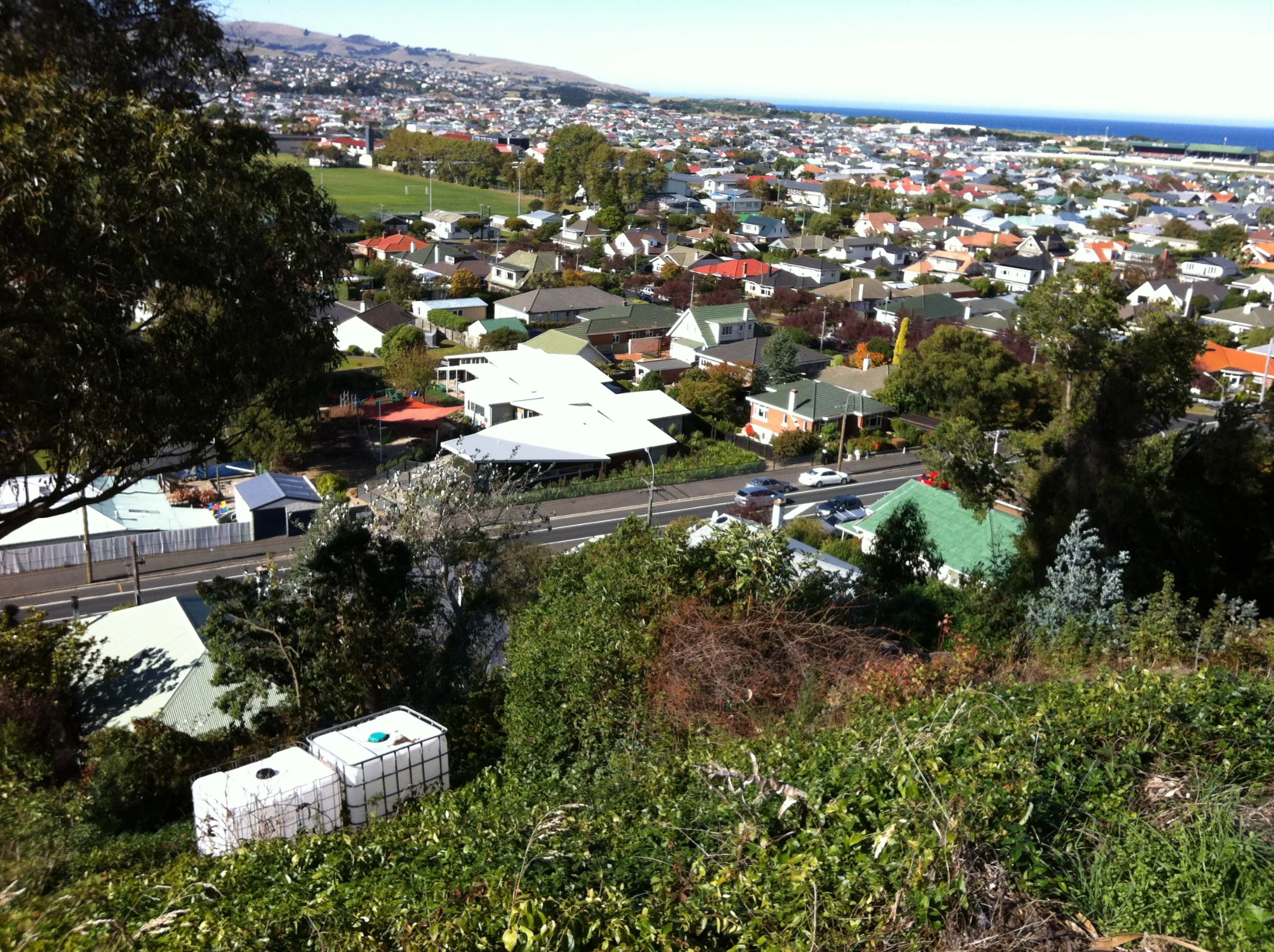
Figure 1: Urban development on the south Dunedin flatlands, 10 April 2016. Photo: Janet Stephenson
I spent an afternoon walking around the large flat urban area that lies between the base of the Dunedin harbour and the southern coast, and includes parts of South Dunedin, Tahuna, Caversham, St Kilda and St Clair. I saw kids playing on their scooters, sports teams in the park, people in their gardens, dog walkers at the beach – similar to many New Zealand coastal towns. From a vantage point, my eye travelled across the dense suburbs edged by the long St Clair and St Kilda beach (Figure 1). I already knew that the area has, by far, the largest number of homes and businesses at risk from rising seas, but it wasn’t until that placid Sunday that I was hit by the sheer scale of the potential impact, and how unprepared we are to deal with its implications. The PCE’s report, ‘Preparing New Zealand for Rising Seas’ identifies that nearly 2700 homes and 116 businesses in Dunedin are at risk from sea level rise of just 50cm, by far the most of any urban area in the country (Figure 2).

Figure 2: Low-lying coastal land in Dunedin. Image from: Preparing NZ for Rising Seas, Parliamentary Commissioner for the Environment (2015), p55
The combination of flat land, low elevation and high water table makes it prone to flooding after heavy rain. A taste of things to come was a flood in June 2015, which went through many homes and left large areas under water for some days (Figure 3). The severity of the event was unusual, but climate change would see this becoming much more frequent. The dunes and St Clair sea wall, which currently provide protection from direct incursion of the sea, have been battered and undermined by heavy seas in recent years. These problems will be exacerbated as high tides become higher, combined with other climate change impacts – more severe weather events, storm surges, coastal erosion, and high and increasingly brackish groundwater. With no interventions, significant parts of the area may well become uninhabitable or unpleasant to live in, over time frames that no one can accurately predict but is decades rather than centuries.
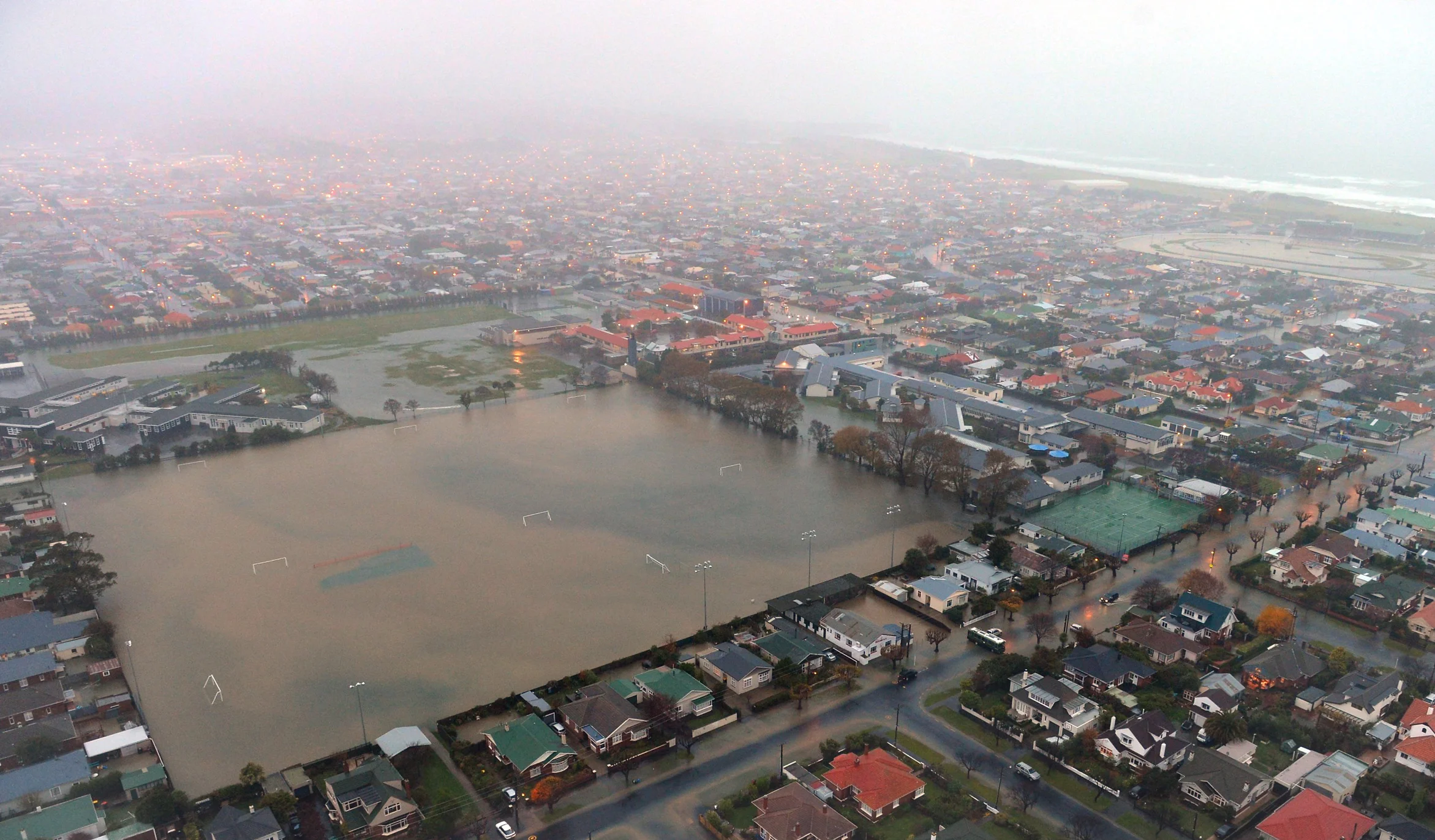
Figure 3: Tonga Park under water in the floods which inundated South Dunedin in June 2015
Photo: Stephen Jaquiery, Otago Daily Times, 16 Dec 2015
How this will be managed in the long term is not yet clear. Will there be technological solutions to rising groundwater and coastal erosion? Will they be affordable for such a huge area and a shifting baseline of change? Or will we see a managed retreat, gradually moving people away from the risk zone and into new housing? Or some combination of these? Importantly, how can the affected community, the people for whom this place is home, be engaged in helping determine the shape of their future?
I believe that a landscape lens can help.
When I refer to landscape, I am not so interested in the physical forms of landscape for their own sake. And to me, landscape is an urban street as much as a wild beach. What interests me is the ways in which the forms and features of landscape become part of the identity of people and communities; the meanings they convey, and the practices they support.
In earlier work, in which I researched cultural values in landscapes, I developed a simple model to represent the ways that community members talked to me about the aspects of landscapes that they valued (Figure 4). The cultural values model suggests that there is a dynamic interaction between valued forms – the tangible aspects of landscape, practices – what people do in the landscape, and relationships – the stories, memories, meanings, spirituality, genealogies and other non-tangible expressions of people-place linkages.

Figure 4: The cultural values model showing the main aspects of landscape values, and how they interact. Image from: The Cultural Values Model An integrated approach to values in landscapes, Janet Stephenson (2010), p 135.
Walking around the south Dunedin flatlands, I found plenty of evidence of these. I saw the forms of the (often narrow) streets, the many parks and schools, modest homes on small sections, the edging of dunes and the long sandy beach of St Kilda and St Clair. I observed the practices of playing, sunning, scooting, beach-walking, sport-watching, surfing. The relationships – harder to characterise without talking with people – were evident in things like street art, gatherings of friends, and the dark shadow of the shark bell – all of which have a past or present story to tell. These forms, practices and relationships reinforce and recreate each other over time. The forms invite the practices, the practices develop the relationships, and the practices and relationships re-shape the forms.
But landscape is more than what we see and experience right now - it is a compendium of what has gone before
But landscape is more than what we see and experience right now - it is a compendium of what has gone before. Forms, practices and relationships of the past are embedded in the landscape of the present.
When Europeans came to Dunedin, this area was a flatland with lagoons, wetlands and sand dunes. For Maori it was a rich source of foods, and a short cut between the harbour and coastal waters. Notice in Figure 5 how far back the dunes used to go, and the reclamations at the head of the Otago Harbour. Subsequently the land was drained and turned into market gardens and small farms, and the coast became a popular recreation area with its long sandy beaches. Then the flat land was urbanised; gridded and overlaid in narrow streets and dense housing. The wide sand-blown hinterlands, the coast’s natural source for replenishing the foreshore, were claimed, filled (often with city refuse) and made over into parks and reserves.
That past landscape is embedded in the landscape of today – in the physical traces such as landforms, archaeological sites, street layouts, locations of parks and buildings. The past is also carried through in the practices that have continued over time, such as beach recreations, sports, and the everyday practices of walking and shopping; and in the stories and memories that are inextricably linked with places. The swamps and farms and market gardens are held in the memory of the landscape.
Figure 5: Pre-1848 map of south Dunedin sketched on to a modern aerial photo of the same area showing the shore lines, lagoons and pre-European features. Image from: Otago Daily Times, Battle of the Dunes article, 1 May 2010.
I try to show this notion of embeddedness in the cultural values model (Figure 6), with the forms, practices and relationship of the past forming the basis of today’s landscape values, regenerating over time but always retaining that time-depth for those who know where to ask and look.
Figure 6: The cultural values model, showing landscape values as a trajectory over time, with opportunities to retain continuity through retaining valued forms, practices and relationships.
So, how does this approach to landscape values help an area like the south Dunedin flatlands face the potentially enormous change over coming decades? I think it invites us to ask three questions about the interlinked trajectory of the past, present and future.
Firstly, can understanding the forms, practices and relationships of past landscapes help us explore possible trajectories for the landscape of the future?
Might parts of South Dunedin eventually return to dunes, swamps and market gardens? In a similar way to how the area was reclaimed from the sea and wetlands, might there be a gradual return to these features as part of the operative ecosystem of the place?
Secondly, what are the currently valued forms, practices and relationships in this landscape, that are part of the identity of South Dunedin, that its community might wish to see retained or reflected in the landscape of the future?
Let us ask community members what is important to them in the current landscape. What stories are embedded here? Stories of fear and bravery, of triumph and accomplishment, or the quiet personal connections of childhood and old age? What features are key for the identity of the place? To the feeling of belonging and community? Its narrow personable streets? Its tiny cheek-by-jowl houses? Places to play and immerse? A racecourse in the middle of the suburb? Places to contemplate or be exhilarated? And what practices are special to this place that the community might wish to retain? Maybe its ease of mobility – biking, walking, scooting? How might the landscapes of the future be designed to try and retain as much as possible of the valued forms, practices and relationships? If houses have to be removed, how might any de-urbanised landscapes be designed so as to honour the past and provide some continuity for the affected communities?
And thirdly, what are the distinctive values of the south Dunedin landscape that its people might wish to see carried over to the new communities that may be formed in future?
This is a much scarier thought, as it means grappling with the unwelcome idea that relocation, or a managed retreat, might be needed for at least part of the population. It shouldn’t be too much of a surprise, though. Low-lying island nations are already having to relocate citizens, and some are seriously planning for a future when they will have to completely abandon their home islands. Looking over the well-established streets of the Dunedin flatlands, it seems somehow fanciful to suggest that the same might happen here. But the evidence suggests otherwise, unless a great deal of money is invested in defences that might ultimately be unaffordable to maintain.
And that being the case, it behoves us to think and plan ahead, just as Pacific Islanders are having to do. We’ve not faced a process of relocation before, apart from in parts of Christchurch, where the community engagement around the red-zoning have been less than ideal. With sea level rise, at least we have some decades to think ahead and prepare. Planning is not just a matter of responding to technical information; it will necessarily involve communities in discovering, understanding, discussing and imagining their future in a slow, thoughtful and inclusive way. From a landscape perspective, this means thinking creatively about whether there are cultural values in the landscape of the Dunedin flatlands that could be carried forward into new future developments away from the danger zone that carry at least an echo of South Dunedin’s identity.
These three questions invite a focus on the interconnections between the past, present and future landscapes. They ask us to consider the ways in which the challenge of climate impacts to community identity and sense of place might be faced through an appreciation of these trajectories and continuities. They invite close engagement with the communities of this place, who are the only people who can tell its cultural values. And by close listening and engagement, it may be that future landscape can retain the practices and relationships that are fundamental to the identity of the Dunedin flatlands, even while the landscape features are gradually being transformed by climate change.
1 IPCC (2014). Climate change 2014 – synthesis report, summary for policymakers, Intergovernmental Panel on Climate Change, http://www.ipcc.ch/pdf/assessment-report/ar5/syr/AR5_SYR_FINAL_SPM.pdf
2 Hansen, J., Sato, M., Hearty, P., Ruedy, R., Kelley, M., Masson-Delmotte, V., ... & Velicogna, I. (2015). Ice melt, sea level rise and superstorms: evidence from paleoclimate data, climate modeling, and modern observations that 2 °C global warming could be dangerous. Atmospheric Chemistry and Physics, 16(6), 3761-3812.
3 http://www.radionz.co.nz/national/programmes/checkpoint/audio/201779457/rising-sea-levels-like-an-unfolding-red-zone-pce-jan-wright
4 Parliamentary Commissioner for the Environment (2015). Preparing New Zealand for Rising Seas: certainty and uncertainty. PCE, Wellington. http://www.pce.parliament.nz/publications/preparing-new-zealand-for-rising-seas-certainty-and-uncertainty
5 Stephenson, Janet (2008): The Cultural Values Model: an integrated approach to values in landscapes. Landscape and Urban Planning 84: 127-139.